Map of the Island of Hawaii University of Hawaiʻi at Mānoa
Resource Title: Map of the Island of Hawaii | University of Hawaiʻi at Mānoa
Organization: University of Hawaiʻi at Mānoa
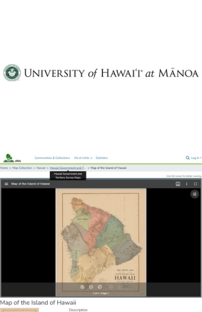
Description:

This resource provides a detailed, high-resolution historical map of the Island of Hawaiʻi, showcasing topography, shoreline, roads, settlements, and land features. Ideal for classroom use, it supports lessons in geography, history, and environmental change over time.

Target Audience: All
Instructional Roles: Enrichment
Environment: Online only (e.g. interactive map), Self-guided
Content Type: Interactive (Online)
Type Of Engagement: Investigate, Observe
Format: Webpage
Activity:
  • Map analysis: Identify mountains, coastline patterns, and major towns, comparing them to modern maps or satellite images.

  • Land-use timeline: Overlay historical land division (ahupuaʻa) boundaries to explore how settlement and land management have changed.

  • Watershed tracing: Examine topography to trace stream networks and watershed boundaries.

  • Then & now comparison: Use digital layers or printed images to compare historical and current land use, noting urban growth, land conversion, and erosion patterns.

Topics Covered:
  • Topographical mapping and contour recognition

  • Historical cartography and land development history

  • Watershed geography and hydrology

  • Land-use change analysis and environmental history

Have a question, found an issue, or just want to connect?
Reach out to us anytime. We're here to help.