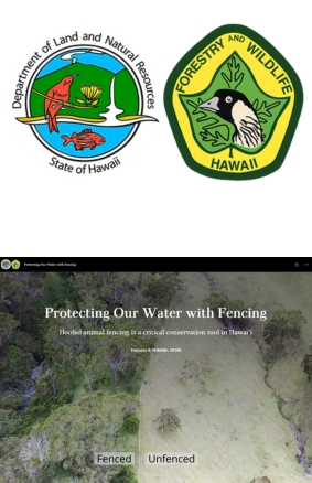
This StoryMap illustrates how strategic fencing of forested areas has been applied to protect watersheds in Hawaiʻi and beyond. It highlights projects showing that every $1 invested in forest fence protection yields approximately $21 in clean water benefits, demonstrating a powerful return on conservation investment.
Map-based analysis:
Explore how StoryMaps combine interactive maps and contextual storytelling to convey conservation successes.
Use the map interface to locate specific fence-protected forest sites and trace nearby watersheds.
Cost-benefit case study:
Students evaluate the $21-per-dollar metric: What types of savings (e.g., reduced treatment, sedimentation, flood control) does this reflect?
Research comparable data—do other regions report similar environmental or economic gains?
Storytelling & communication:
Create a mini-StoryMap focused on a local environment (e.g., a school watershed or community forest).
Combine maps, photos, and captions to convey why that area matters and how fencing could support it.
Watershed protection through fencing: how excluding ungulates and other threats supports forest regeneration and water quality
Ecosystem services valuation: translating ecological restoration into measurable economic benefits
GIS & digital storytelling: effective use of interactive StoryMaps for environmental communication
Place-based conservation: understanding how ecological interventions at a local site support broader regional resilience